On most of the planet this quake would have been unremarkable, but having shaken a population exceeding 7 million people, it earned some remarks. In fact, in the 24 hour period surrounding this earthquake there were 27 of similar or larger magnitude around the world, but this one earned the attention. (That link will probably update with time… if you need convincing you can just set up a “custom data feed” for March 11, 2013.)
The screen grab below shows all M4+ earthquakes that occurred on March 11, 2013. Most of these went unnoticed. Some were felt by many, but didn’t receive the (U.S.) coverage of the SoCal tremor.
I love seeing the bimodal reactions of southern Californians to an earthquake of this size. No doubt the unnerving sensation of the ground suddenly shuddering beneath you is frightening to many, but there seem to be just as many who could scarcely care less.
Watch as it disrupts (or doesn’t) the coverage of the nearby Indian Wells BNP Paribas Open tennis tournament:
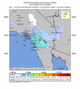
The other interesting facet of the quake was the initial determination of its location and magnitude, which was ironically marred by having a sizeable precursory foreshock, a sizable and immediate aftershock, and great instrumental sensitivity/coverage. At the outset, seismic waves from the foreshock and aftershock, which were separated from the mainshock by 16 and 51 seconds, respectively, tricked the automated system into mislocating the source and origin time of shaking. Initially the USGS identified three earthquakes with magnitudes ranging from 4.7-5.1 that occurred within two minutes of each other. Of course to most of the populace that distinction in the wavetrain would have scarcely been discernable. It was moot anyway, because as the system and seismologists further processed additional data the true sequence of events became clear. A 2.3… 16 seconds… a 4.7… 51 seconds… a 3.0. Meanwhile the shaking from each of those was rippling outward through the L.A. region and desert, overlapping with each other in their rattling. This confusion is an interesting artifact of having a great, quickly responsive seismic network… that’s not quite dense enough to pick out the details of everything it detects right away.
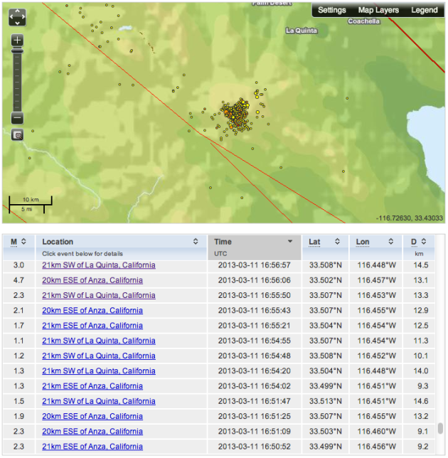
Southern California’s dense seismic network allows detection of minuscule earthquakes, so there is a rich foreshock and aftershock sequence evident surrounding the mainshock hypocenter. Viewing the list of foreshocks makes me intensely curious about the nucleation process of larger earthquakes.
Foreshocks and aftershocks in the 2 days before and after Monday’s quake
The L.A. Times has a good informative piece about the quake and its regional significance as expressed by USGS scientists:
The M9.0 Tohoku earthquake that roared through Japan on March 11, 2011 made its presence felt in various ways throughout the planet. The ground rippled, the ocean churned, and even the atmosphere undulated with heavy pressure waves as the force of this sudden lurch of the Earth’s crust radiated outward from its source off the coast of Japan.
[Put your headphones on now.]
Scientists all over the world have taken data of all stripes and turned them into illustrative visualizations–like the examples listed above–of the extent of this seismic event. Most of these are old news, but for some reason I thought of them today, so here they are for your illumination.
One of the most captivating effects of this earthquake–and of any–is the aftershock sequence it unleashed. Aftershocks represent the relief of intense local stresses left by the abrupt perturbation of a mainshock, and they unfold in a statistically predictable manner (there’s a fun presentation by USGS scientist Karen Felzer explaining the remarkable features of aftershock sequences here). Despite this statistical order, in our relatively fast-paced human timescale, we may still perceive them as startling and chaotic, especially when we’re on edge in the aftermath of a major quake. Sped-up animations of earthquake occurrence (“seismicity”) help illustrate the decay in frequency and size of aftershocks with time, as well as simply illustrating just how numerous they may be after a large mainshock.
This video shows one year of earthquakes greater than magnitude 4.5 around the globe. Many mainshock-aftershock sequences are apparent, but by far the most spectacular is the series of quakes that is induced by the gargantuan Tohoku earthquake. Enjoy.
This same group has produced several other videos, either covering different time spans, or zooming in to Japan. Have a look at their website:
One of my favorite videos of this flavor is the “sonification” of seismic records from the day of the quake, like the one at the beginning of this post. Earthquakes shake the ground at frequencies lower than human hearing (infrasonic), but if we simply speed up the playback of seismic records, and translate their motions into oscillation of a speaker cone, we get the “sound” of the earthquakes. In that “sonification” video you see seismograms from four different stations in Japan and Russia that record the mainshock and the onslaught of aftershocks–including a 7.9–that follow. The inset map shows energetic yellow glows surrounding each station that are scaled to reflect the amplitude of the seismic waves recorded there.
If those aren’t enough coolness for you, there’s a whole page of different “sonifications” compiled by a Georgia Tech researcher illustrating different phenomena associated with the monster quake. Several of the clips play regional recordings of the mainshock and its aftershocks, but the compilation continues into recordings from the other side of the planet, where seismometers in California recorded the San Andreas Fault creaking and shuffling with triggered tremor as the long slow elastic waves from Tohoku swept through.
A seismic record section and frequency spectrogram show the first hour following the Tohoku quake. Click the image for the movie with audio. Quicktime format. The link to other videos and formats is below.
If you’re into these sorts of things, there are more to be found… The California Integrated Seismic Network has some sped-up recordings of the 2004 M6.0 Parkfield earthquake and its aftershocks, at http://www.cisn.org/special/evt.04.09.28/sounds.html
A new video from Japan [embedded below] shows liquefaction occurring at a scale and scope that I haven’t seen before in video footage. The video is from Urayasu town, Chiba Prefecture–an industrial suburb of Tokyo that appears to be sited on made land adjacent to Tokyo Bay. No wonder it sloshes so heavily: made land (fill) is particularly susceptible to liquefaction. We just can’t pack things down the way nature can over millennia.
The video starts in the aftermath of the March 11, 2011 M9.0 Tohoku earthquake, where sediment-filled ground water is bubbling up through gaps in the pavement, or any other fractures that represent escape routes. Within minutes, the M7.9 aftershock hits, and you can see light poles, trees, and buildings shaking violently. All the while, the engineered infrastructure sloshes and bobs, essentially floating on a thick package of fluid-saturated mush. The differential swaying you observe is effectively the dramatic reduction of seismic wave velocity in the loose, fluid-supported substrate. The sound you hear is largely the metal guard rails creaking as they’re stretched and bent. The oscillations last for a very long time.
Liquefaction commonly accompanies large earthquakes in areas where a shallow groundwater table supports suspension of soft soils when it’s shaken. I’ve posted videos of the phenomenon before. It occurs during any earthquake that strikes an area with the right mix of water-saturated sediments. It was widespread throughout Christchurch in each of their big jolts in 2011, and occurred pervasively in the shoreline areas of Japan during their monstrous 2011 quake. Fractures opened during shaking provide conduits for this newly mobile soil slurry to escape surface-ward under the weight of dry material above, producing sand volcanoes, like the one pictured in the righthand image of this blog’s banner.
After watching these videos, it’s clear why this phenomenon results in such destruction, particularly to pipelines and underground utilities. Water main failures may add to the fluid pressure mobilizing all the soil.
When you hear about the danger of living on “fill” and the destruction of liquefaction, these illustrative clips should come to mind.
200 years ago this February 7, on the western frontier of European settlement in North America, the pioneering westward expanders and the natives whose land they were colonizing were thrown from their sleep in the deep wee hours of a winter night by the culminating temblor of a harrowing, months-long sequence of major earthquakes, aftershocks of which continue to this day.
Map of shaking intensity interpolated from historic accounts of the 2:15am mainshock of the New Madrid sequence. Map courtesy Susan Hough, USGS.
The so-called New Madrid earthquakes–named for a small Missouri settlement near the modern-day borders of Kentucky, Tennessee, Illinois, Indiana, and Arkansas that lay nearest the center of this cataclysmic seismic sequence–are the largest to have struck the eastern United States since well before they became the United States. In the recorded history of western settlement of North America, no quakes outside of the mountainous west match them in size and scope, and only a few come close.
Plenty of peoplehave been and will be reporting on these earthquakes as we celebrate their bicentennial, including the organizers of the Great Central U.S. ShakeOut, which took place this morning to commemorate the massive culminating temblor of the sequence that started in December 1811. Even mapping software purveyor ESRI has put together a commemorative compilation of informative and beautiful interactive maps about the quakes (super cool compilation! If you click on one link in this post, let it be that one). It is worth reading some of these syntheses and reviews because the earthquake series itself makes a captivating narrative. It’s nearly impossible to imagine the terror with which these relentless temblors must have stricken the settlers, who were already braving the “wild” frontier of a foreign continent. Even the mid-continent’s native inhabitants had not experienced such a thing in scores of generations, and in the early 19th century no one would have had any reasonable framework in which to explain the occurrence of massive earthquakes.
Because the New Madrid quakes occurred so early in our country’s recorded and geographic history, piecing together the events with a modern understanding of earthquakes and plate tectonics has required a great deal of sleuthing, and some of the details gleaned about them remain controversial, most notably their magnitudes (were they more like M7 or more like M8?). The uncertainty regarding the exact size of these earthquakes compounds the issue of determining the seismic hazard posed by recurrence of major earthquakes in the New Madrid Seismic Zone. To understand how seismicity may continue in southeastern Missouri we can look for patterns in the prehistoric record of earthquakes, but ideally we would like some idea of what forces caused these earthquakes to happen here. This remains an open question, and one in particular for which the question of the quakes’ magnitudes may be a crucial bit of information. Researchers have tried to use modern seismicity to constrain the behavior of large earthquakes in the New Madrid Seismic Zone, and some have interpreted the ongoing small quakes there as the tail end of an unsurprising aftershock sequence, suggesting that they don’t represent heightened seismic risk, but that in fact New Madrid is as likely as any number of other places in the eastern U.S. to have more major temblors.
The ongoing scientific controversy over ambiguous interpretation of details of these quakes stems from the nature of the data. Researching “pre-instrumental” earthquakes is a pursuit that fuses seismology, history, and social science, in an effort to understand historic written accounts of the earthquakes in the context of their time and cultural setting. A somewhat recent article in Seismological Research Lettersdescribes the endeavor of anecdotal seismology, and through some colorful examples illustrates how historical reports can be translated into seismological data, clarifying the sources of interpretive ambiguity. The marriage of historical and seismological research to inform our model of seismic events in the eastern U.S. could be and has been the subject of many volumes, so I can’t hope to cover it here.
Instead I’ll draw analogy to this incredible sequence of earthquakes through videos and pictures from recent events, hopefully grounding some of the legendary accounts in footage of real and recognizable phenomena.
To the extent that people have learned about the New Madrid earthquakes of 1811-1812, they have often heard of them referred to as the largest quakes to ever strike the U.S. Ask California [1857 & 1906] and Alaska [too many to name] and you’ll find this claim is far from true. Along with this hyperbolic appraisal comes the legendary confluence of phenomena eyewitnesses allegedly reported: the Mississippi running backwards, giant fountains of water issuing from the Earth, trees being thrown to the ground, and land sinking into the river. The unimaginable chaos of these phenomena all occurring in the midst of violent shaking defies belief, but contemporary earthquakes and modern video recording technology allow us to ground them in reality, and perhaps to understand them as more modest individual events that have been amplified in intensity by their conflation and coincidence in legend. We can see examples of all four in much more modest earthquakes:
1. The Mississippi running backwards
It’s difficult to imagine what possible physical phenomenon could have led to this observation/claim… unless you understand that the New Madrid quakes–just like all other large temblors–resulted from slip along several geologic faults. At the surface, fault slip breaks and displaces the ground, moving one side in a direction opposite the other. In the case of the causative Reelfoot Fault, the surface trace cut right across the Mississippi River channel, dropping an upstream portion of the river relative to the adjacent reach downstream. This warping has been thoroughly investigated and modeled, and thanks to the September 4, 2010 Darfield earthquake–a M7.1 event that ripped across rivers on New Zealand’s flat Canterbury Plain–we have a beautiful modern analog of the occurrence.
Aerial view of the Horata River spilling off of the fault scarp formed by the September 24, 2010 Darfield earthquake in New Zealand. Image courtesy Dr. Mark Quigley, University of Canterbury, Christchurch, NZ.
Where the 2010 NZ rupture fault sliced across the Horata River, it diverted the water into surrounding farmland, effectively changing the course of the flow. This is precisely analogous to the diversion of the Mississippi that led to both the damming and formation of Reelfoot Lake, and the temporary diversion of river flow back upstream.
2. Fountains of water issuing from the Earth
There are a few processes that may combine to produce this effect. In the past year we’ve seen plenty of examples of sand volcanoes, the eruptive results of shaking-induced soil liquefaction. When subjected to seismic waves (as in this New Zealand aftershock, or the Tohoku quake below), these sand blows can be squeezed into fountains of substantial height. The force of a larger and longer earthquake would undoubtedly increase the height these reach.
Extrusion of liquefied sediment by seismic waves isn’t the only coseismic phenomenon that may throw water high into the air: seiching–harmonic oscillation–of small bodies of water may throw water against their banks and up into the air. We’ve seen this dramatically demonstrated in swimming pools during a M7.2 earthquake, but natural ponds don’t necessarily have the splashing power of sharp corners and hard edges in concrete-walled pools. Nonetheless, with these two phenomena operating in tandem, the amount of water being thrown into the air by the quake would certainly be fodder for tales–legendary or not–of high fountains from the Earth.
3. Trees being thrown to the ground
Videos from several modest (M ~6) earthquakes in the past few years have revealed just how much trees can be wrenched around during shaking. Under the accelerations of earthquakes, trees’ own weight can be a more powerful force than high winds. Here a stand of neighborhood trees sways in a mere 4.4 earthquake in Christchurch:
In a M6 we see through the windows the same effect:
Finally, video the USGS captured at practically the epicenter of the M6.0 2004 Parkfield earthquake shows fairly violent lashing of late summer oaks in the California Coast Ranges.
A tree along the San Andreas Fault in Wrightwood, CA, had its top snapped off in an 1812 earthquake, from which it grew two new crowns. The tree no longer exists, but others like it can be found along the 1906 rupture near Point Arena in NorCal. Image from "Mixed Matters"
Though the effects shown above do not amount to trees being thrown to the ground, the earthquakes that produced them were much smaller than the ones that struck Missouri. We have clear evidence along the San Andreas Fault of trees whose tops were snapped off during the 1906 earthquake. This is a common effect in the epicentral region of large quakes.
4. Land sinking into the river
This phenomenon is akin to but distinct from the Mississippi being diverted and running backwards. In fact the underlying process is more closely related to the processes that give rise to sand blows. Shaking liquefies water-saturated soils and they lose their shear strength, rendering them unable to support gravitational loads. Thus the land slumps, under its own weight or the weight of trees, houses, or riverboat moorings, downhill towards unencumbered free edges like river banks. This “lateral spreading” is commonly observed along river banks shaken by earthquakes, and results in lowering and inundation of the ground surface. Examples abound from earthquakes as geographically and tectonically various as the 1964 Good Friday event in Alaska, the 1906 San Francisco earthquake, the 2010 Haiti earthquake, and the 2010 El Mayor-Cucapah earthquake. In all of these events vast swaths of land shook loose and slumped ocean- or river-ward, and effectively “sank”.
The video examples compiled above may not match the apparent drama of those recounted from 1811-12 Missouri, but I find it easy to imagine the cumulative results of decades and decades of re-telling on the details of these accounts. In any case, large earthquakes produce remarkable effects, and although many people around the world witness or experience earthquakes, still relatively few witness the truly violent shaking that occurs near an earthquake’s source. Written and oral accounts give us the most thorough picture, even if we have to take them with a grain of salt. Video may gradually be replacing verbal accounts in objectivity (no relying second-hand information!), but it has yet to become as widely distributed and available as individual eye-witnesses.
Next time you strike up a conversation about these earthquakes, consider yourself informed about many of the features that defined them, but by all means gather more information on your own. My two favorite informative links are the following:
Christchurch, New Zealand, has suffered its fourth day (and 5th, 6th, and 7th big quakes) in barely over a year of what continues to be a brutal onslaught of seismicity. It began in September, 2010, with a magnitude 7.0 earthquake outside of town that caused billions of dollars in economic losses. The vigorous aftershock sequence of that quake was punctuated in February by a magnitude 6.3 earthquake east of the September rupture patch. This quake struck a direct hit on the city, killing 181 people and devastating the central business district. The liquefaction caused by these two quakes [pdf] has flooded and destabilized vast swaths of neighborhoods around Christchurch. After months of additional aftershocks, a 5.5 rattled the city in June, followed within hours by another M6.0, both yet farther east. The two of these caused additional destructive liquefaction throughout the city. They have been having their own series of aftershocks, compounding the tremors being felt as a result of the largest prior two quakes.
Earthquakes in the Canterbury sequence September 2010 - November 2011, colored by intervals between the dates of the largest quakes. Note the eastward migration of the concentration of seismicity. Green represents the September 2010 M7.0 Darfield quake and aftershocks; Red represents the February 2011 M6.3 Christchurch earthquake and aftershocks; Blue represents the June Port Hills quakes and aftershocks.
Cumulative number of earthquakes near Christchurch plotted over time. After each of the major quakes, the aftershocks die off in frequency at very predictable rates... but keep getting interrupted by new big quakes!
Just before 2pm on December 23, as locals were no doubt greeting out of town relatives for a warm, summer Christmas, they were struck by a hefty magnitude 5.8 offshore, east of previous quakes. A couple moderate aftershocks followed on its heels, and 8 minutes later there was a 5.3. About an hour and a half later, in the midst of a whole slew of modest aftershocks, one of these turned into a 6.0 and rocked the city hard. There have been literally hundreds of aftershocks since then, including another M5.1. Cantaburians and their Christmas guests have undoubtedly managed very little sleep with the incessant jostling, and it takes no stretch of the imagination to understand how exasperated they must be with the relentless quakes. There’s a nice post at Highly Allochthonous about the tectonics of these quakes, and The Landslide Blog discusses some of the notable features of these two new quakes and their implication for quake-related politics and policies in Christchurch. I’ll jump into the mix here with a collection of footage from the latest events!
The following videos capture what each of these latest quakes was like, and the gasps, sighs, and exclamations as residents reveal their exhaustion from the continuous trauma of not knowing what to expect from each new tremor that hits. ALL of these videos show beautiful separation of the P- and S-wave arrivals, in other words the rumbling versus the shaking. The warning from the extra few seconds of rumbling is thanks to the quakes’ location offshore and thus their relative distance from the city.
This family’s camera was running when the December 23 sequence started; it captured the 5.8, and they arrive home at the tail end of an early modest aftershock (after 02:15 in the video):
The camera’s still running, and they’re trying to calm the nerves with a beer when the M6.0 hits. Not a great way to help cool the nerves–this guy’s surprise is evident.
Next, one of the clearest videos showing the strong shaking of the 6.0:
Here’s the raw footage of a clip commonly replayed on the news, from the newsroom itself. Again, this is a scene of the M6, so they’ve already been shaken–physically and emotionally–by a few. You can see the exasperation:
Another clip commonly replayed on the news:
This next clip documents a far greater–but still pretty much justifiable–sense of panic. It’s actually heartbreaking to see how it begins with a news report in the background about the 5.8, optimistically trying not to jinx themselves by saying the quakes have died down over the hour. It helps illustrate why the M6, the largest of the three that day, was so demoralizing. Careful, there’s a hefty dose of adult language. Who can blame him?
A rattling kitchen (these folks have things well secured!):
Here’s a set of videos from security cameras in various places. There’s a whole lot of lurching during passage of the surface waves.
Another shot widely replayed on the news shows a woman darting from a shaking storefront.
The following video is from a supermarket, and shows the chaos of the quake as well as the exasperation of the beleaguered residents.
This family captures the quake from outside as they warn their children of more danger. It may sound like bleak consolation for the kid, but Dad’s right: nature has been nothing if not ruthlessly unpredictable here.
Several eye-witnesses of the March 11 M9.0 in Japan have posted chilling first-hand footage of their experiences. The following two videos document the entire disaster, from the shaking until deep into the tsunami.
First, here’s the harrowing video taken by a professional storm chaser who happened to be in Otsuchi, Japan doing volunteer work for Save Japan Dolphins when the earthquake roared along the coast. He struggles to keep his balance at the tail end of the earthquake, then they hop in their car and spend eight precious minutes fleeing to high ground with the rest of the alarmed population. These guys are clearly professionals; they have incredible composure. As they navigate their way through town you hear radio correspondence with a second car behind them full of other dolphin activists, the Sea Shepherds. While the tsunami roils its way into the bay from the open ocean, the water level creeps up and floods the seaside industrial buildings. As usual with footage of the tsunami, it keeps on coming, getting higher and higher against all belief.
This next video is unprecedented: a high-def dashboard camera in a bus records the entire event, most of it from in/on the tsunami! It was recently recovered, and we get to witness its journey. It would be marvelous if someone who knows Japanese could do a little translation of this report. Watch this; the following text is a spoiler.
It’s incredible to watch as the bus helplessly bobs with mounds of urban flotsam, but the literally immersive perspective reveals fascinating gradients in the velocity and height of the tsunami’s flow as it rages through city streets. The bus seems for a while fortunately stuck in an eddy behind a huge concrete building… until it gets entrained in a rapid flow and slammed up against something, at which point debris pierces the windshield, water rushes in, and the camera dies.
There’s at least one more street-level recording of the tsunami pouring into town. Once again what begins high and dry ends up so far below water it defies imagination.
Yesterday I posted a few videos of the large pair of quakes that struck Christchurch once again on Monday. Since then a few more have surfaced showing the 6.0 as it happened. Clearly even the earthquake-worn residents of Christchurch were startled by such a large temblor.
This man’s home suffered some damage in the 5.5 earlier, so he set up a camera while he went about his business. Sure enough he was startled by a quake “worse than the last one”, recorded here. There’s a very nice separation between the P- and S-wave arrivals here, allowing him plenty of rumbling warning before the real lurching starts. As the shaking winds down you can still hear his stuff being jolted and see the lamp being yanked around as seismic waves continue bouncing around the jello-like sedimentary basin beneath the city.
This kid has similarly coincidental timing, and captured the whole thing unfolding with his family at home. Dad earns some accolades for keeping cool and lookin out for the kids:
A New Zealand Herald reporter was out and about interviewing–presumably about the earlier 5.5–when the 6.0 rocked the neighborhood street where the interview was happening. They witness the liquefaction-mobilized silty water start gurgling out of the ground and flooding the neighborhood; surely an eerie and helpless feeling:
Unfortunately this is a case where the incompatible timescales of tectonics and humanity collide. These quakes do not signal any sort of new tectonic regime nor indicate that the seismic behavior of the region has changed. They merely represent an unfortunately prolonged little geological burp–a transient period during which a little bit of strain that must be accommodated is occurring in insufficient fits every couple of months. Eventually Christchurch will quiet down, with earthquake recurrence once again far below that of plate-boundary-adjacent regions like Japan, California, Alaska, Chile, the Himalaya, Indonesia, and the west side of their own South Island, to name a few. Until then the population faces a very real hardship: more destructive earthquakes may dot the near future, and the soupy emissions from liquefaction are gradually unsettling foundations across the region. These are problems residents will have to make serious decisions about. Unfortunately human time scales can’t wait on geology to quiet down.
It may be decades before another earthquake generates as much eye-witness footage as the 9.0 Tohoku monster in Japan, but there’s a fair bit from some neat vantage points in New Zealand during this latest quake. One interesting aspect many of these videos offer is the comparison of duration and intensity between the shaking from the 5.2 “foreshock” and the 6.0 that followed.
A back yard is rattled by the 5.2 (nice shot of the trees getting yanked around, and a mini-seiche in the pool):
This lucky lad turned his camera on just in time for the foreshock:
A widely publicized clip shows the earlier earthquake interrupting a Maori ceremony:
This home surveillance system captures both quakes in full… with 4x the vantage points!
And finally, this Kiwi man is tiptoeing around the toppled contents of his house following the “biggie” while aftershock upon aftershock inhibit any feeling of settled comfort. His heavy use of reflexive verb formulations takes a lot of the blame for the destruction away from the Earth and lands it on the more direct culprits: poorly secured cabinets and appliances! Nonetheless the ongoing tremors remind him/us who’s in control. This is when you ask yourself when it will stop. If we only knew…
[Updated]: A few more videos of the 6.0 are collected in my next post.
Hope you’re getting rest and respite, Christchurchians, or at least finding some way to get on with life through the bucking of the Earth!
I stumbled upon a fascinating video a couple of weeks ago showing what happens to sand volcanoes as seismic waves pass. This would have fit in either my aftershocks or my liquefaction posts from last week, but it’s both stunning and unique so I decided it deserves a post of its own.
This New Zealand man is filming sand blows forming from liquefaction of a school yard in the 22 Feb M6.3 earthquake, when a large aftershock hits. Shaking from the aftershock isn’t immediately visibly apparent, but shrieks and metallic rattling herald its onset. Once the sharp noisy shaking is over, the ground continues undulating, apparent only in the fissures opened from liquefaction. As the seismic waves from the aftershock compress, dilate, and otherwise jostle the ground, the fissures feeding the sand blows open and close, alternately squirting silty water out and drawing it back down–along with the air above.
Quite a phenomenal illustration of the ground’s undulation. The sight of this lends credence to some alleged eye-witness reports of the 1811-1812 Missouri earthquakes, which claim that as the ground heaved, “fissures opened and slammed shut… spewing water high into the air.” Reports like this (especially from random websites) tend to suffer from the telephone syndrome, in which subtle modifications by a series of reporters lead to misinformation. So take the accounts in that link with a grain of salt; perhaps I’ll compile legitimate resources on that fascinating earthquake sequence in a future post.
No doubt most people’s most recent earthquake-related thoughts pertain to last week’s temblor in New Zealand. Of course as we’ve all heard this was a particularly unfortunate event because of the location and modest depth of its source: merely ~5km below the streets and only a few measly kilometers from the city’s dense and populous center. We’ve all also heard it described as an aftershock of a bigger quake last September, a quake which used to be “the big Christchurch earthquake”. Many people may be surprised to hear such a significant event deemed an aftershock, so let’s explore aftershocks for a bit.
There’s a more technical spin-off discussion here, which Chris Rowan has done a marvelous job covering in a post on Highly Allochthonous. He examines the difference between an “aftershock” and a “triggered earthquake”. The gist of his distinction between the two is that aftershocks are earthquakes that occur adjacent to a large rupture due entirely to the immense change in stress accompanying the rupture; triggered quakes are those that were bound to happen in the near future and only required a small change in stress (provided by a large rupture nearby–or perhaps distant) to let loose. Triggered earthquakes are a fascinating subject, but for now let’s just talk about aftershocks and related earthquake sequences as a whole.
Firstly, have a look at this interactive map of the Christchurch earthquake sequence, put together by Paul Nicolls at New Zealand’s University of Canterbury. Atop a Google Maps applet the series of earthquakes appear through time, colored by depth and sized by magnitude–a fascinating way to visualize how this sequence of seismic events unfolded. Notice the conspicuous bursts of activity following the largest events.
One of the most unsettling aspects of major earthquakes is that they are followed by literally thousands of subsequent tremors. People who have been traumatized by the first violent temblor are virtually constantly beleaguered by the startling jolts of subsequent tremors. You begin to get a sense of the incessant rumblings in this couple’s video of the quake damage at their house: there are aftershocks at 0:43, 1:43, 3:08, and 4:53 in the clip. Don’t mind the swearing, it’s natural.
After September’s quake, the ongoing sequence of aftershocks became a fact of life in and around Christchurch. The following three videos show some of the bigger aftershocks preceding the 6.3. As far as New Zealander’s knew, they were dying down.
In the immediate aftermath of a large quake, this constant shuddering can understandably be much more alarming. Other than rattling already frayed nerves and doing further harm to damaged buildings [minute 2:55], the big problem–as illustrated in Christchurch–is that location is important. If the 6.3 had started where the 7.0 did, it would indeed have been less trouble than the original quake. Instead it occurred at the near end of the September rupture, supplying a much sharper dose of strong shaking to the city than they had been subjected to by the somewhat removed mainshock.
When a large earthquake occurs (what makes an earthquake turn into a large one and not just stop at a tiny M3 is a frustratingly unknown part of the earthquake process, and it drives lots of debate as well as lots of research) it drastically alters the stress in the crust around it (see pretty pictures at the bottom), requiring major adjustments of the surrounding rock. Imagine tightly crumpling a plastic grocery bag and leaving it on the floor for it to slowly crackle and unfurl until it’s sufficiently unconstricted to settle calmly. That’s more or less what goes on after the huge readjustment of the crust in an earthquake. Each of those little crackles is a new earthquake–an aftershock–generally smaller than the original. In fact, after decades of recording earthquakes, we’ve found that aftershocks follow very regular patterns. Over time the likelihood of having an aftershock of a certain magnitude drops logarithmically. That doesn’t mean that over time they become smaller, it means that it rapidly becomes less likely that you’ll have a biggish one. It still may happen. No wonder people’s nerves are on edge; they should be! In many parts of the world earthquakes are an inevitable reality. Earthquakes beget other earthquakes. Large seismic events initiate a cascade of yet unpredictable seismic shifts, and it pays to be mentally and physically prepared.
I'm a Ph.D. student in earthquake geology, using topographic and stratigraphic investigation to unravel the seismic history and dynamic behavior of continental faults. I get excited about all things seismological, and I bring them to you here.


 Big quakes in the past week
